IHTA Seminar 2017: Mapping Townscapes
When
Friday, May 19, 2017, 09:45Where
Tickets

IHTA Seminar 2017 – Mapping Townscapes: comparative perspectives through the Irish and British Historic Towns Atlases
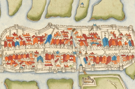
Early maps and town plans are vital sources in understanding townscapes and are used to create historical maps that form such an important element of all historic town atlases. In collaboration with the British Historic Towns Atlas/Historic Towns Trust (HTT), the 2017 annual seminar of the Irish Historic Towns Atlas (IHTA) focuses especially on historic and historical maps. The Mapping Townscapes programme begins with an evening public lecture on Thursday 18 May at 6pm in the Royal Irish Academy by Professor Roger J.P. Kain, a leading cartographic historian and author, whose most recent book British town maps: a history appeared in 2015. It is also free to attend, but booking necessary to secure your place.
Looking at urban mapping in both Britain and Ireland across five centuries, the Mapping Townscapes seminar will open up new comparative perspectives on the Irish and British historic town atlases, as well as offer new insights into the past, present and future cartographic connections between our two neighbouring islands.
For the full programme, please click here.
Attendance is free, but booking is essential as it usually books out prior to the RSVP date. Please click here for booking details.
In association with the Irish Walled Towns Network.
You might also like...

Discourse Series | The future of the EU: Bigger and Better?
When: Thursday, 23 May 2024Join us for a conversation between Mairead McGuinness (EU Commissioner, 2020-24) and broadcaster Olivia O’Leary MRIA.
Reading and collecting books in early modern Ireland and Europe
When: Wednesday, 15 May 2024Dr Elizabethanne Boran and Professor Brendan Dooley describe the landscape of reading and book collecting in early modern Ireland and Europe
Irish Historic Towns Atlas Seminar 2024: 'Marshland to Metropolitan City'
When: Wednesday, 15 May 2024This event is fully booked, but a waiting list is in place. The annual IHTA Seminar, 'Marshland to Metropolitan City: exploring Cork through the Irish Historic Towns Atlas' will take place in Cork on 15 May 2024.