New Collection: Waterford City Maps
07 April 2022The Digital Repository of Ireland (DRI) is delighted to announce that the Waterford City Maps Collection is now available through the Repository.
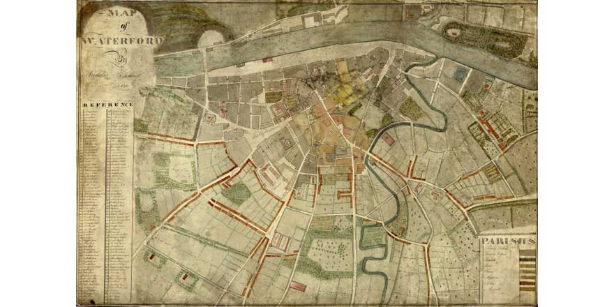
The Waterford City Maps Collection,, which has been made available by Waterford City and County Council, consists of seven high definition, highly detailed maps of the city environs that date from the late seventeenth century to the beginning of the twentieth century. The maps track not only the growth and development of this major Irish port city and its neighbourhoods, but the technical developments which were arriving in Ireland such as the railway, telegraph, and electricity.
Waterford City and County Archivist Joanne Rothwell said:
Waterford City has a rich and storied history and the surveys and maps in this collection from Waterford City and County show the development and expansion from walled town to merchant city. These surveys and maps are part of the collection of what was then Waterford Corporation. The Corporation commissioned surveyors, such as William Leahy, to map and survey the City and also the Corporation lands in the City and surrounding areas. The maps and surveys continue to be an important resource for Waterford City and County Council and will hopefully be of benefit to researchers and historians as well.
These maps contain marvellous detail about Waterford City. As well as mapping city wards that were used for electoral and policing purposes, the location of graveyards, thatched cottages, forests and even boreens can be seen in these maps. Together they give us an impressive picture of how Waterford developed from the seventeenth to the twentieth century and what life was like for the inhabitants of the city.
DRI Director Natalie Harrower said:
We are delighted to see this collection made available through the DRI. The extraordinary detail contained within the maps can be explored through the Repository’s IIIF viewer which brings the city streets to life, showing us what life was like for Ireland’s urban inhabitants in the past. The collection joins a growing body of maps in the Repository, which are a useful resource for historians, geographers, archaeologists, local historians, and really any cartology enthusiast. I would urge you to browse this wonderful collection.
You can explore the Waterford City Map collection at this DOI
You can find out about more new collections by subscribing to our newsletter or following us on Twitter or Instagram.
Image Credit: Nicholas Sinnott. (2022) Map of Waterford City 1830, Digital Repository of Ireland [Distributor], Waterford City and County Council [Depositing Institution], https://doi.org/10.7486/DRI.jq08k912p
You might also like...

Irish Persistent Identifier (PID) roadmap project - upcoming community events
19 April 2024During May and June 2024, the National Open Research Forum (NORF) and the MoreBrains Cooperative will present a series of community events on the Irish Persistent Identifiers (PIDs) Roadmap Project.

New DRI Collection: Rose from the Heart
16 April 2024The Digital Repository of Ireland (DRI) is pleased to announce that a new collection – Roses from the Heart – has been published in the Repository through South East Technological University.

New DRI Member Case Study – RIA Publications
27 March 2024The Digital Repository of Ireland (DRI) is delighted to publish another information brochure in our Case Studies series. These studies offer an in-depth, detailed examination of some of the challenges facing our members...