
Digital Atlas of Dungarvan to be launched as part of Heritage Week
24 June 2020The Irish Historic Towns Atlas (IHTA) announces the launch of the Digital Atlas of Dungarvan as part of Heritage Week (15–23 August 2020), where the theme this year is ‘Learning from our heritage’.
The Digital Atlas of Dungarvan will be launched on 18 August 2020 ahead of the publication of the printed atlas — IHTA, no. 30, Dungarvan/Dún Garbhán — which is due for publication in December 2020.
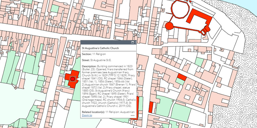
The new digital atlas is an interactive map that allows users to explore the urban heritage of the town of Dungarvan in their own way. Freely available and accessible online, it provides layers of historical maps that show how the town plan has changed over time. A specially digitised base map shows the town in 1841, where detailed historical information on over 700 individual sites has been incorporated and is available in pop-up boxes (see above). In this way, features of the past townscape, such as the long disappeared medieval defensive walls, are revealed and may be examined alongside more familiar streets and buildings. The Heritage Council has asked communities to explore ‘Heritage on their doorstep’ for this year’s Heritage Week — Dungarvan residents, students and visitors are invited to do just that via the Digital Atlas of Dungarvan.
The Digital Atlas of Dungarvan will be available here from 18 August 2020.
A short video on the Digital Atlas project can be viewed here.
Image (top): Market day, Grattan Square, Dungarvan, c. 1900 (Lawrence Collection, National Library of Ireland).
The Digital atlas of Dungarvan is the result of a collaboration between the Royal Irish Academy, Waterford City and County Council and Ordnance Survey Ireland. It has been created using Arc GIS Online and will be launched during Heritage Week, 15–23 August.
You might also like...

Raymond Gillespie MRIA
09 February 2024
We are deeply saddened by the death of our editor and colleague, Raymond Gillespie MRIA, on 8 February 2024.

New online Digital Atlas of Cork/Corcaigh launches today
05 December 2023Today marks the launch of the Digital Atlas of Cork/Corcaigh, a free online interactive map that invites you to discover the built heritage of Cork City in a new way where 6,245 features of the city's history from AD...
Town & Country launch and 'Mapping places, mapping people' lecture
23 November 2023Town & Country: perspectives from the Irish Historic Towns Atlas was launched by Vanessa Harding, chair, Historic Towns Trust last night following a lecture by Howard Clarke 'Mapping places, mapping people: Dublin...