
New atlas publication: Clontarf by Colm Lennon
06 December 2017Downloads
Irish Historic Towns Atlas, Dublin suburbs, no. 1 Clontarf by Colm Lennon is availble to buy now.
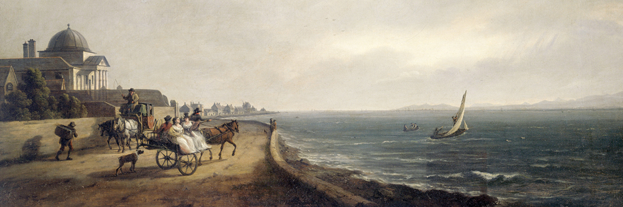
['The Royal Charter School, Clontarf, County Dublin' by William Ashford, 1794. National Gallery of Ireland, 577]
Irish Historic Towns Atlas, Dublin Suburbs, no. 1 Clontarf by Colm Lennon was officially launched by Lord Mayor Mícheál Mac Donncha on Wednesday 6 December 2017 in Academy House. Colm also delivered a lecture to a capicity crowd to celebrate the launch of Clontarf.
This new historical atlas of Clontarf, the first of the IHTA Dublin suburbs series, promises to reveal the unexpected. For those familiar with the well-loved suburb and its seafront, and for all enthusiasts of Dublin’s history, Clontarf traces the development of a small port village to a modern city suburb in a specially designed format. A dedicated section displays historic maps (from 1673) that allow readers to discover changes over time in unusual detail. Text is interspersed with early views and reconstructions, and a gazetteer of streets and buildings gives potted histories of over 900 local sites that, while known to many, still retain an element of surprise.
Clontarf is the first in a series of atlases devoted to Dublin suburbs under the auspices of the Irish Historic Towns Atlas project and is available in all good bookshops; Nolan’s and Spar shops in Clontarf and online here.
For the press release please click here.
Photos from the lecture and launch
Watch an interview with author Colm Lennon
Series editors: Colm Lennon, Jacinta Prunty; Cartographic editor: Sarah Gearty; Editorial assistant: Angela Byrne; Design: Fidelma Slattery
Softback, 260 x 355 mm, colour, illustrated
€30/£28/$40
Maps prepared in association with Ordnance Survey Ireland
Published by the Royal Irish Academy in association with Dublin City Council
You might also like...
'Making St Brigit real in the early middle ages' by Elva Johnston
01 February 2024Brigit has been treated differently to Irish male saints, becoming a secondary character in her own biographies, reductively overshadowed by a barely attested goddess.
Knowth megalithic art volume and related resources added to ‘Excavations at Knowth’ collection in the DRI
30 November 2023The megalithic art of the passage tombs at Knowth, County Meath, by George Eogan MRIA and Elizabeth Shee Twohig MRIA, is now available as an online, open access resource in the Digital Repository of Ireland.