
Explore Grangegorman before the institutions
13 June 2022Downloads
Raymond Gillespie, MRIA is Professor of History at Maynooth University. His main research interest is social change in early modern Ireland. In this article, Professor Gillespie shares the history of the unusual landscape that was Grangegorman from 1400 to the 1700s, before the institutions.
An early nineteenth-century traveller in search of information on Grangegorman would almost certainly have turned to the recently published An historical guide to the city of Dublin by G.N. Wright. There, the traveller would have learned that Grangegorman was a manor (it would not become a parish until 1829) that lay in the neighbourhood of Glasnevin and Mountjoy Square; that the lord of the manor, though not the owner of the land, was the dean of Christ Church cathedral; and that the manorial courts were still held by the seneschal in a private house on Dorset Street, at the corner of North Circular Road. The population of the manor was 6,035 within the Circular Road and 6,072 outside it, all housed in 1,277 houses (1). This rather bland description conceals the fact that the urban landscape of Grangegorman was unusual. Rather than a vista of spreading suburban housing in a rapidly growing city, Grangegorman was composed of large, open spaces with a scatter of institutional buildings and more densely packed houses along a few central streets. That unusual landscape was the product of almost 200 years of evolution that contributed to make Grangegorman a unique place.
Origins
The most important factor in shaping Grangegorman in the early middle ages was its grant to the cathedral of the Holy Trinity [Christ Church] by Sitric Silkbeard, the Scandinavian ruler of Dublin, on the foundation of the cathedral in 1030; the grant is recorded in a later charter that was transcribed in the sixteenth century.(2) It is not known what area this Grangegorman covered but it was certainly smaller than the later manor: the property was augmented by a grant from Hugh Hussey, lord of Galtrim, who had been given the surrounding land in c. 1185. The result was a new unit: the manor of Grangegorman with its manorial courts and other legal attributes. It is difficult to be sure exactly what the area of the manor was, but it seems very likely that when the new parish of Grangegorman was created in 1829 it followed, roughly, the boundaries of the manor that was then still in existence. Despite a dispute with Richard Tyrell, lord of the manor of Castleknock, in the late 1180s, Grangegorman remained under the control of Holy Trinity until the sixteenth century.(3)

The extent of the parish of Grangegorman as created in 1829.
The parish boundary probably coincides closely with the medieval manorial boundary.
The evidence for the appearance of Grangegorman before 1400 is rather patchy. Only one account roll that sheds some light on the manor has survived in the Christ Church archive. Part of the explanation for this is the destruction of the Christ Church archive, but much was never preserved in the cathedral because the manor was run as a self-contained unit with its own seneschal, bailiff, sergeant, courts and records (although the prior of Holy Trinity visited and stayed on a number of occasions), and these records have not survived. Of the 800 acres that was recorded as the extent of the manor in the seventeenth century, rather less than half was under cultivation in the late 1320s, and this would shrink slightly in the 1340s. The remainder was under pasture or woodland. The main crop of the manor was wheat, grown on south facing, well-drained slopes, with a much smaller crop of oats. Of the wheat, roughly one-third was used for seed, one-third was sent to Holy Trinity and one-third was consumed on the manor. The oat crop was used mainly for malting, a task often carried out by women, with a small proportion used as fodder for horses.(4) There are few mentions of livestock (and those refer mainly to ploughing) in the surviving accounts but cattle and sheep must have existed, if only to provide manure for the arable activity, and pigs, ‘as stock’ were mentioned in 1346.
The land was managed directly by Holy Trinity priory as one demesne and worked by the inhabitants. Some of these were free tenants who held some land for which they paid a cash rent. A rental from 1326 names four of these men. Much more common were the cottiers—seventeen being named in the rental—who held a cottage and perhaps some land for which they paid in labour services to the manor; ploughing, sowing or reaping or carting at harvest.(5) They included three ploughmen, a plough driver, two carters, a lime burner and a thrasher. The centre of this manor was a large enclosure or farmyard, probably ditched and fortified, with an entrance gate, dominated by a large barn to hold grain. There were almost certainly other agricultural buildings in this enclosure, together with a house for the manorial officials.
A late medieval world
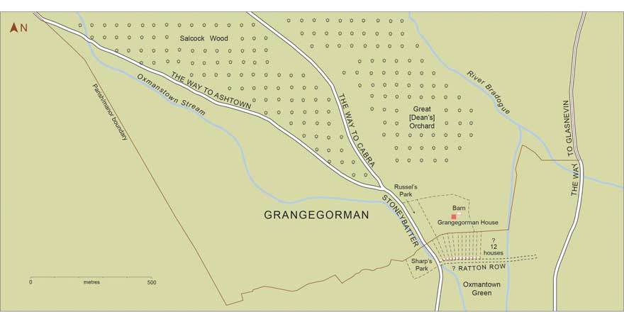
Southern Grangegorman in the fifteenth and early sixteenth centuries.
The topography of Grangegorman comes into clearer focus in the fifteenth and sixteenth century.. A survey of the manor, probably made in the late sixteenth century, divided it into three parts: the lands to the west of Stoneybatter (or ‘the way to Cabragh’), the lands to the east of Stoneybatter and the northern third of the manor.(6) The land to the west of Stoneybatter would seem to have been mainly arable as this was described in the riding of the franchises of Dublin in 1488 as the ‘tylling land’, and in 1603 as ‘the arable land of Grangegorman’.(7) On John Rocque’s map of Dublin in 1756 this part of the manor is shown as neatly laid out in strips, which may be at least partial survivals from the medieval arrangement whereby large open fields were worked in strips.
Extract from John Rocque, An exact survey of the city and suburbs of Dublin (Dublin, 1756),
showing possible relic layout of medieval strips in Grangegorman to the west of Stoneybatter.
The land to the east of Stoneybatter, in contrast, appears to have been used mainly for grazing, and a large part was occupied by the ‘Great Orchard’ or (as it would become) the ‘Dean’s Orchard’, which was partly wooded and was still so in 1811.)
The third part of the manor, the northern part (roughly from Cabra Road northwards), was occupied by Salcock Wood, rather over 50 acres of woodland.(8) This was an important resource that provided both shrubby wood and furze for firewood—important as turf was not available locally—and more substantial timber for building and agricultural tools. The woodland cover was dense enough to allow it to be used for hunting and, according to a later account, in 1573 the earl of Desmond escaped from custody in Dublin on the pretext of hunting at Grangegorman.(9) Salcock Wood was leased to a series of individuals who were expected to manage it, and unauthorised cutting of timber was a serious offence.(10) Nevertheless, by the early eighteenth century it was almost cut out.
A glimpse of the manor is provided by a rental of 1496–7 that suggests that the older forms of tenure had disappeared and most tenants now held their own farms either directly from the manor or as subtenants from a few larger tenants, such as John Russell. Houses, at least a dozen, had begun to grow up along the southern edge of the manor where it met Oxmantown Green. What these houses looked like is unclear, but one lease of 1485 stipulated that the house to be built on the plot had to have mud walls and a straw roof. The centre of the manor remained the enclosed farmyard that was described in a lease of 1560 as having a barn, kiln, sheepfold and cowhouse.(11)
Changing control

The open landscape of the eastern part of the manor of Grangegorman, from Thomas Campbell, City of Dublin
surveyed by Mr Thomas Campbell under the direction of Major Taylor ([Dublin], 1811).
In the early sixteenth century, rather than working the land itself, Holy Trinity had taken to leasing the entire manor to one man, as in 1543 when it leased Grangegorman to Mathew King.(12) Holy Trinity or Christ Church remained the lord of the manor, however, and it held the manorial courts into the nineteenth century. Sometime before 1557 the royal adventurer and later secretary of Lord Deputy Sidney, Francis Agard, had acquired a lease of the manor of Grangegorman from Christ Church cathedral. In 1560 he used his influence to have that converted into a series of fee farm grants of the manor.(13) Agard died in 1577 and was buried in Christ Church and the property passed to his son-in-law Henry Harrington. On his death the property seems to have reverted to the Agard family and a John Agard held it in 1640. This meant that the manor now acquired a resident landlord who required a house. Agard constructed one on the site of the old barn in the manorial centre; parts of this still survive in Stanhope Street and were revealed in excavations in 2014. It was clearly a substantial structure valued at £40 in the 1650s, though curiously it does not appear in the hearth money rolls of the 1660s.(14)
In the late 1640s the land passed out of the direct control of the Agard family and at the Restoration the manor was partitioned into two parts, roughly east and west of a line following Stoneybatter and continuing northward to the edge of the manor. In the 1670s the western portion was sold to Sir John Temple, extending his estate at Palmerstown and Kilmainham eastward, and that family, as Lords Palmerston, continued as ground landlords into the nineteenth century. The eastern division, comprising some 250 acres, was sold in 1668 by Charles Agard to the Stanley family and this in turn was sold to the Monck family (who were related to the Stanleys by marriage) in 1737.(15) The Monck family shortly after acquired a house at Charleville in Wicklow and left Grangegorman, abandoning the house there.(16)
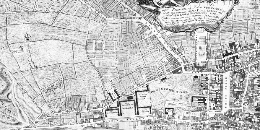
Throughout the seventeenth and eighteenth century the manor remained an important source of grain production for the city. The civil survey of the 1650s, for instance, recorded that of the 800 acres of Grangegorman, 500 were devoted to arable, 200 to pasture and 100 to meadow.(17) A windmill, probably for grinding grain, existed in the south-west corner of the lands by the late sixteenth century and continued in use into the eighteenth century.(18) There was also an unofficial local market at Grangegorman selling food to the city.(19) It is clear that by this stage the manor was divided up into individual rent-paying farms and in the 1640s some farmers reported substantial losses of cattle in the wars of those years.(20) However, many of these farms were small. A survey of 1788 of the Monck portion of the manor revealed the average size of the forty-nine holdings to be only five acres, with only four holdings being greater than ten acres.(21) The smaller plots were concentrated nearest to Stoneybatter while those to the north and west were somewhat larger. Plots of this size were not viable as farms and might best be seen as rural retreats for the inhabitants of an expanding city.
In the years after 1660 suburban Dublin on the north side of the River Liffey expanded dramatically. Oxmantown Green, which had marked the southern boundary of the manor, was built over, leaving only a small fragment of the earlier open space. Yet this desire for expansion never spread into Grangegorman. By the time of Rocque’s map of 1756 a cluster of houses had developed in the older holdings of Sharpe’s Park and Russell’s Park, but little else. Thomas Campbell’s map of 1811 shows yet more housing along Stoney Batter, Aughrim Street and Prussia Street, much encouraged by the Monck family, but large areas of the manor were still empty with trees still prominent in the formers Dean’s Orchard.
This open aspect may well have survived the eighteenth century because of the rise of the recreational role of the manor rather than its agricultural potential. The Church of Ireland clergyman Nathaniel Burton in 1845, remembering the late eighteenth century, wrote that many ‘tired of the bustle of the city’ retired to rural retreats at Grangegorman ‘amidst decaying woodlands and increasing orchards. Cabra lane [now Prussia Street] became a desirable and fashionable retreat’, renowned for its ‘genuine milk and dairy air’.(22) It was this open aspect, however, that made it attractive for the development of the new institutions that did so much to shape Grangegorman in the nineteenth century.
Notes
- G.N. Wright, A historical guide to the city of Dublin (2nd edn.; Dublin, 1825), p. 116.
- Charles MacNeill (ed.), Calendar of Archbishop Alen’s register (Dublin, 1950), p. 28.
- M.J. McEnery and Raymond Refaussé (eds), Christ Church deeds (Dublin, 2001), nos 195, 469.
- Margaret Murphy and Michael Potterton, The Dublin region in the middle ages (Dublin, 2010), pp 308, 314, 414.
- James Mills (ed.), Account roll of the priory of Holy Trinity, Dublin, 1337–1346 (reprint, Dublin 1996), pp 192-4; H.J. Lawlor,’A calendar of the Liber Niger and Liber Albus of Christ Church, Dublin’, Proceedings of the Royal Irish Academy 27 (1908–9), pp 49, 50.
- Representative Church Body Library, MS C6/1/26/1 no. 2.
- J.T. Gilbert and Lady Gilbert (eds), Calendar of the ancient records of Dublin (19 vols, Dublin, 1889–1944), vol. i, pp 196, 494.
- Representative Church Body Library, MS C6/1/26/1 no. 3.
- James Ware, The antiquities and history of Ireland (Dublin, 1705), p. 17.
- Christ Church deeds, nos 1105, 1179, 1195.
- Christ Church deeds, nos 1072, 1105,1114, 1180, 1268, 1275, 1545.
- Representative Church Body Library, MS C6/1/26/1 no. 2.
- James Morrin (ed.) Calendar of the patent and close rolls of chancery in Ireland: Henry VIII to 18th Elizabeth (Dublin, 1861), p. 433; Christ Church deeds, nos 1250, 1266–9, 1311–2, 1421–2.
- See www.excavations.ie (accessed 22 February 2022); R.C. Simington (ed.), The civil survey, vol. vii, county of Dublin (Dublin, 1945), p. 179. For the house on the site of the barn, see Gilbert (ed.), Calendar of the ancient records, vol. i, p. 197.
- Elizabeth Batt, The Moncks and Charleville House (Dublin, 1979).
- National Library of Ireland, MS 26899, ff 1–5, University of Southhampton Library, Broadlands papers, BR 137/23, 24; BR 151/1–5.
- Simington (ed.), Civil survey, vol. vii, county of Dublin, p. 179.
- Representative Church Body Library, MS C6/1/26/1 no. 2; Christ Church deeds, no. 578.
- Gilbert (ed.), Calendar of the ancient records, vol. iv, p. 512.
- For instance, see Aidan Clarke et. al. (eds), 1641 depositions: vol. iv, Dublin (Dublin, 2017), nos 496, 521.
- National Library of Ireland, MS 26887.
- Nathaniel Burton, Oxmantown and its environs (Dublin, 1845), p. 3.
Raymond Gillespie, MRIA
Professor of History, Maynooth University
You might also like...
Grangegorman Lives: James Celestine Carr
08 April 2024Our Grangegorman Lives series continues with James Celestine Carr, a prominent radiologist.
Grangegorman Lives: Sir William Stokes
05 April 2024The next addition to our Grangegorman Lives series is Sir William Stokes, a surgeon born to the pioneering cardiologist William Stokes.
Grangegorman Lives: Fleetwood Churchill
05 April 2024Our Grangegorman Lives series continues with Fleetwood Churchill (1808 – 1878), the Nottingham-born obstetrician and medical writer.