Galway Exhibition
When
Monday, July 3, 2017, 10:00 - Thursday, November 30, 2017, 17:00 |Where
Tickets

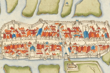
Galway's history through maps: an exhibition through maps and views.
The history and development of Galway through maps and images are now on display in the Meeting Room of the Royal Irish Academy. The exhibition panels explain where Galway got its name from and its influence as a military, maritime, trading and industrial centre on the western seaboard.
As part of the Irish Historic Towns Atlas, no. 28 Galway/Gaillimh launch by President Michael D. Higgins in November 2016, this exhibition in collaboration with Galway City Museum was on display in the museum and ran for a number of months. The exhibition, in English and in Irish, highlights Galway's rich cartographic history, which shows its development from it's earliest times as a strategic crossing point to modern times. It gives insight into its merchant and military past as well as the development of the suburbs, including the Claddagh, and use of water power. While much development has occurred in Galway in the twentieth and twenty-first centuries, the medieval core has changed very little since the thirteenth century.
Opening hours: 10am to 5pm, Monday to Friday, except on conference days (14 July, 1 September, 21 September) and the Library annual clean (31 July to 4 August). See Library landing page for exceptions. Free admission, no booking necessary.
You might also like...

Discourse Series | The future of the EU: Bigger and Better?
When: Thursday, 23 May 2024Join us for a conversation between Mairead McGuinness (EU Commissioner, 2020-24) and broadcaster Olivia O’Leary MRIA.
Reading and collecting books in early modern Ireland and Europe
When: Wednesday, 15 May 2024Dr Elizabethanne Boran and Professor Brendan Dooley describe the landscape of reading and book collecting in early modern Ireland and Europe
Irish Historic Towns Atlas Seminar 2024: 'Marshland to Metropolitan City'
When: Wednesday, 15 May 2024This event is fully booked, but a waiting list is in place. The annual IHTA Seminar, 'Marshland to Metropolitan City: exploring Cork through the Irish Historic Towns Atlas' will take place in Cork on 15 May 2024.