-

Further resources for researchers, students and teachers.
-
Irish Historic Tows Atlas, no. 19 Dublin, part II, 1610 to 1756 by Colm Lennon was originally published in 2008.
-
Irish Historic Towns Atlas no. 1 Kildare by J.H. Andrews was originally published in 1986.
-
Irish Historic Towns Atlas no. 28 Galway/Gaillimh by Jacinta Prunty and Paul Walsh was originally published in 2016.
-
Irish Historic Towns Atlas no. 5 Mullingar by J.H. Andrews with K.M. Davies was originally published in 1992.
-
GIS-based projects using IHTA material.
-
Irish Historic Towns Atlas, no. 9 Bray by K.M. Davies was originally published in 1998.
-
Irish Historic Towns Atlas no. 4 Kells by Anngret Simms was originally published in 1990.
-
Tuesday, 4 October 2022, 10:00 – 16:45 IST.
Venue: Academy House -
Irish Historic Towns Atlas, no. 24 Sligo by Fióna Gallagher and Marie-Louise Legg was originally published in 2012.
-
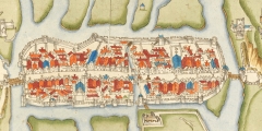
Marshland to metropolitan city: exploring Cork through the Irish Historic Towns Atlas
-
Irish Historic Towns Atlas no. 17 Belfast, part II, 1840 to 1900 by Stephen A. Royle was originally published in 2007.
-
Irish Historic Towns Atlas no. 20 Tuam by J.A. Claffey was originally published in 2009.
-
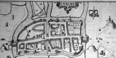
The Digital Atlas of Cork/Corcaigh is an interactive map that invites online visitors to discover the city of Cork in a new way by exploring early maps of different dates and detailed...
-
Irish Historic Towns Atlas no. 14, Trim by Mark Hennessy was originally published in 2004.
-
This digital edition of the Irish Historic Town Atlas for Kilkenny is available below for you to explore online.
-

The City of Derry was ‘UK City of Culture’ in 2013. To mark this the Irish Historic Towns Atlas, Royal Irish Academy have collaborated with Derry City Council and the School of Geography,
-
Irish Historic Towns Atlas no. 8 Downpatrick by R.H. Buchanan and Anthony Wilson was originally published in 1997.
-
Irish Historic Towns Atlas no. 3 Bandon by Patrick O'Flanagan was originally published in 1988.
-
Towns of monastic origin reflect their early monastic heritage in their layout. Their continuity as a settlement site was often interrupted and they were later re-founded or expanded into urban centres.
-
The Digital Atlas of Galway is the result of a collaboration between the Irish Historic Towns Atlas project in the Royal Irish Academy, Maynooth University and Ordnance Survey Ireland.
-
Irish Historic Towns Atlas no. 18 Armagh by Catherine McCullough and W.H. Crawford was originally published in 2007.
-
Irish Historic Towns Atlas no. 12 Belfast, part I, to 1840 by Raymond Gillespie and Stephen A. Royle was originally published in 2003.
-
The Viking and later Hiberno-Norse town, evolved largely from pre-existing Gaelic settlements and Viking longphort or ship encampments in the ninth and tenth centuries.The urban settlement developed into a defended town.
-
The topographical gazetteer and further study maps for Irish Historic Towns Atlas: Dublin Suburbs no. 1, Clontarf by Colm Lennon and no.2 Rathmines by Séamas Ó Maitiú are available for download. You will need the code on the colophon (copyright and publishing information) page ...
THE ROYAL IRISH ACADEMY IS IRELAND'S LEADING BODY OF EXPERTS IN THE SCIENCES AND HUMANITIES
The Royal Irish Academy/Acadamh Ríoga na hÉireann champions research. We identify and recognise Ireland’s world class researchers. We support scholarship and promote awareness of how science and the humanities enrich our lives and benefit society. We believe that good research needs to be promoted, sustained and communicated. The Academy is run by a Council of its members. Membership is by election and considered the highest academic honour in Ireland.
Read more about the RIA